Federal Workers in New York State Collectively Earn More than $16 Billion Annually
Interactive Mapping Tool Shows Federal Workforce in NYS
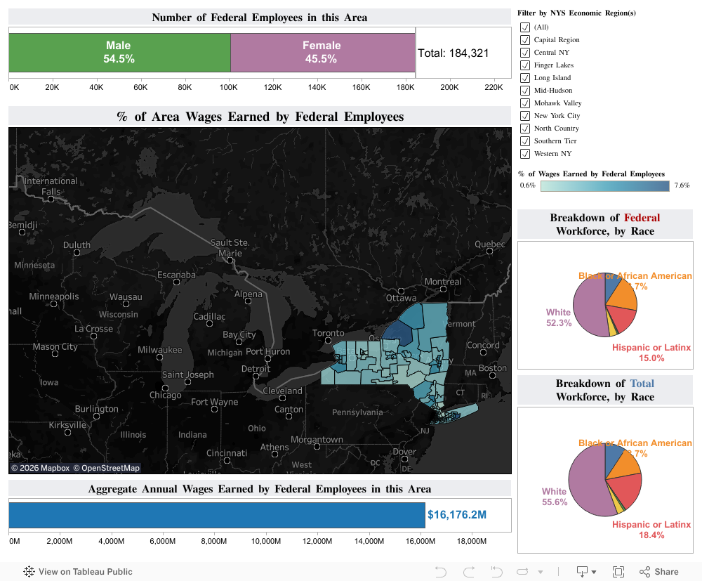
In response to the April 9th, 2025 U.S. Court of Appeals decision that “cleared the way” for the federal administration to resume firing federal employees, the Cornell ILR School's Buffalo Co-Lab and Center for Applied Research on Work (CAROW) developed an interactive mapping tool and data visualization to show the number and distribution of all federal employees in New York State (NYS), as well as the purchasing power that such workers derive from their government jobs.
The tool, which appears below, uses data from the current (2019-23) U.S. Census Bureau Five-Year American Community Survey (ACS) Public Use Microdata Samples (PUMS) to show concentrations of federal workers and federal workers’ purchasing power across NYS.*
Key findings from analyzing these data include:
- Nearly 185,000 NYS-based workers are employed by the federal government;
- Federal workers living in NYS are disproportionately persons who identify as Black or African American (such persons are roughly 19% of federal workers, but just 12.7% of all workers living in NYS);
- Collectively, federal workers living in NYS earn nearly $16.2 billion in wages, accounting for significant purchasing power throughout the state; and
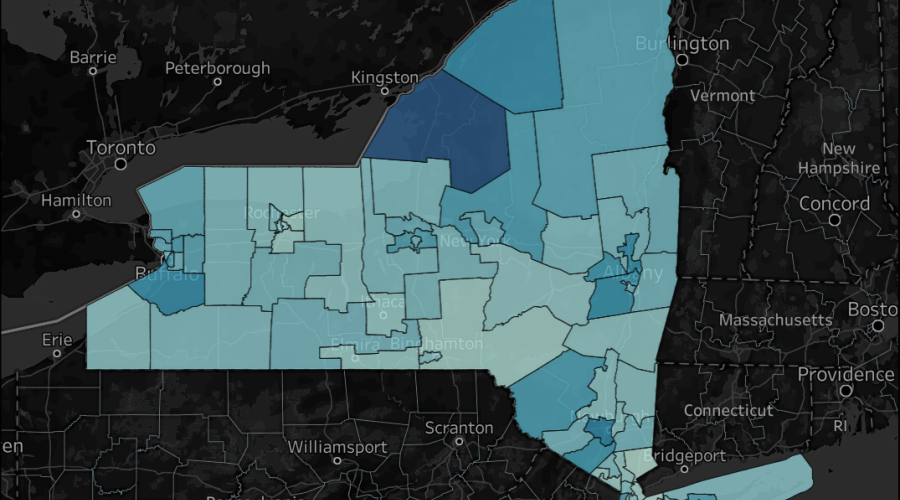
- The highest concentrations of civilian federal workers and civilian federal worker earnings in NYS are located in: (a) Jefferson and Lewis Counties in the North Country, where Fort Drum is located; and (b) the Brookhaven and Upton areas of Suffolk County, where the Internal Revenue Service and Brookhaven National Laboratory (an arm of the U.S. Environmental Protection Agency) are two of the top local employers. Roughly 8% of all wages earned by workers in these locations can be attributed to federal government employees.
Access the tool below. The checkboxes in the top-right can be used to filter the data and zoom the map to one or more desired NYS Economic Regions. Likewise, single-clicking an individual location on the map — where the geographic units are U.S. Census Bureau Public Use Microdata Areas (PUMAs) — will filter the data for that particular location.
*Because the Five-Year ACS PUMS dataset receives an annual update in January of each year, the interactive map cannot capture real time changes in the NYS federal workforce as layoffs or hiring occurs. However, CAROW plans to refresh this tool with current data during the first quarter of each year, following the annual PUMS release.
This NYS Federal Workforce interactive tool is also available on Tableau Public.